Drones bring in forest data that used only to be dreamed of

Using drones will help boost the processing value of wood, as the quality of wood can be assessed even before felling.
New drone technology makes it possible to measure the quality of wood of standing trees. This is an important advancement: so far, Finland’s forest resource data does not include quality indicators for individual trees or stands.
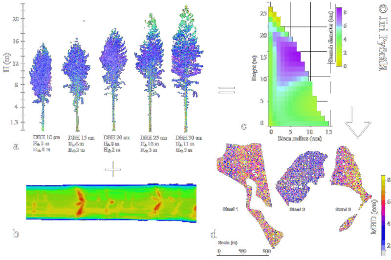
In the Quality4Trees project led by Professors Markus Holopainen and Juha Hyyppä, forest researchers are developing automatic remote sensing methods based on laser scanning. Laser scanning is a non-invasive measuring method using laser beams to determine accurate 3D data. The project has received funding from the Research Council of Finland.
Drones gather data on trees
Drones flying below tree crowns gather detailed data on the trees, and this has been successfully combined with open-access forest data maintained by the Finnish Forest Centre and the log x-ray data from sawmills. Maximizing the data available before felling will help to improve the processing value of wood.
’Our vision is to accumulate data covering the whole of Finland on what sort of trees grow where,’ says Markus Holopainen.

The potential to improve the processing value of wood with laser scanning would be useful for the forest bioeconomy in general, as well as for both businesses and forest owners. It would also be beneficial to forest ecology, since a better financial result could be obtained with smaller-scale fellings.
As to Finland’s forest resource data, Holopainen considers it to be the best in the world.
’It’s not on the same level everywhere, which means that with things like carbon storage data, for example, we can serve as a research laboratory,’ Holopainen says.
According to Markus Holopainen, data gathered by drones can in the future be used to determine the age, size and health of a tree, as well as factors affecting quality. These include, for example, the stoutness and shape of the trunk, which are of interest to sawmills, bent or crooked trunks, the size and distribution of branches, wood density, species, and the geography and climate of the site.
’In our research we have been able to make precise measurements of indicators related to wood quality, but to produce practical applications, we need more research in collaboration with forest companies and other organisations in the sector,’ Holopainen says.
Drones can also gather data on the health and biodiversity of forests.
Portable laser scanners
In addition to drones, measurements can be made in the forest with laser scanners either placed on a stand or fitting into a backpack. Precise measurements on individual trees, taken inside a stand, can be extrapolated to cover a larger area with the help of remote sensing from above, using drones, helicopters, air planes or satellite imaging.
Using data on branches, the growth of a tree can be predicted even down to cellular level. Because a forest is growing and in constant change, the laser scanning must be repeated every five or six years.
The new technology would also be advantageous in harvesting. Future visions include electronic timber trading that might make site visits unnecessary. This would bring added value to the processing chain, stumpage payments and the cost of harvesting. The forest companies collaborating with the project are Metsä Group, Stora Enso and UPM.
’Timber deals, for example, can be concluded without visiting the forest. Just by making small steps in the right direction, we can achieve great financial savings,’ says Holopainen.
Read more: Use of AI in the forest sector illustrated in six images
