Forest Indicator measures nearly 40 variables in nature – promotes multiple-goal use of forests
Natural Resources Institute Finland (Luke) has created an indicator for comparing the different uses of forests. The Forest Indicator rings together such things as biodiversity, ecosystem services and timber production to compare the impact of operations on each.
The multiple-goal use of forests involves a balancing act between different benefits. The Forest Indicator allows the assessment of what activities might enable the simultaneous production of timber and safeguarding of biodiversity or improving carbon sinks and berry yields, for example.
The Forest Indicator is a regional-level tool for the use of authorities in particular, to assess the impact of different felling scenarios. It can, however, be used by anyone from forest owners to forest planners when assessing the impact of operations in the forest.
In contrast, it is not designed for assessing impact on smaller units such as forest compartments.
The Forest Indicator makes use of data from the National Forest Inventories. It describes calculated data on tree stock, biodiversity and natural products like berries, among other things. Biodiversity is described by data on key plant groups and species in forests: grasses, forbs, lichens, and the dwarf shrubs bilberry, lingonberry and heather.

Only the beginning
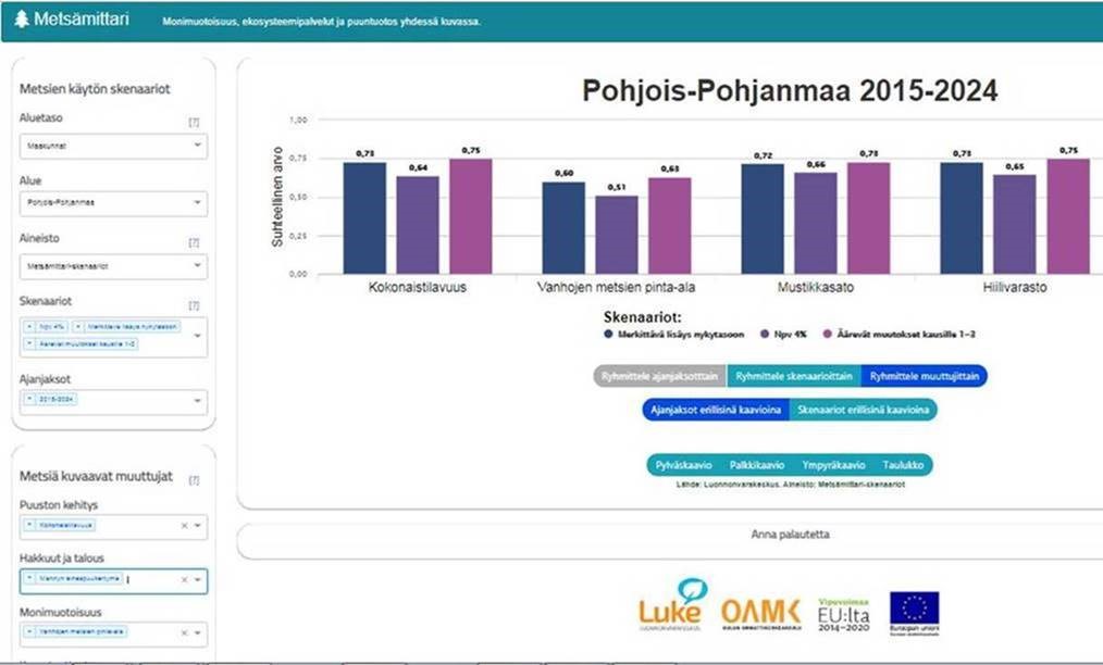
In practice, the Forest Indicator is a web page where users may view the impact of felling plans by selecting the length of observation period, the felling scenario and the variables that they wish to examine. Thus, the input of numerical data by users is not required; they simply choose between the options given.
The results are presented as graphics, showing the proportionate values of the variables and the changes in them.
This solution was adopted because the units and scales used to measure the different variables are different. The original values are found through Natural Resources Institute Finland Luke’s Mela tool, and they can be used to calculate forecasts of absolute change.
For Professor Anne Tolvanen from Luke the recently-published Forest Indicator is only a good start. Ideas for developing the tool abound, including how to improve its visual look and interactivity.
’There’s a lot that is not yet included, and we have no shortage of development ideas and things to improve. One of the easiest tasks could be to calculate the recreational value of a forest and the forest potential,’ Tolvanen says.
Based on plenty of calculation
The Forest Indicator was developed by Luke in collaboration with the Oulu University of Applied Sciences and the Finnish Forest Centre. The technical application was developed by students and staff of the Oulu University of Applied Sciences.
The indicator is based on a number of substantial data sets. The development took place in the North Ostrobothnia and Lapland regions.
’In future we will extend the use to other regions and to the whole of Finland,’ says Research Professor Tuula Packalen from Luke.
The Forest Indicator was tested in connection with the revision of the regional forest programmes for North Ostrobothnia and Lapland, and it was found to work well. Extending its use to other regions will not pose difficulties.
’When drawing up regional forest programmes, the Forest Indicator would appear to be useful for assessing the impact of forest operations,’ says Tolvanen.
’Developing the Forest Indicator required collaboration across the boundaries of disciplines and administrative sectors,’ Tolvanen says. Workshops arranged by Luke and the Finnish Forest Centre provided useful input.
These workshops brought together participants from numerous stakeholder groups, including the Finnish Wildlife Agency; the Centres for Economic Development, Transport and the Environment; the 4-H organisation; the Finnish Environment Institute; Metsähallitus and local nature conservation associations.
Thanks to this, the Forest Indicator is already part of public debate on forests.
The Forest Indicator is part of the UUTU (New Products from Forests) project, co-funded by the European Union’s European Rural Development Fund. The collaboration also included the University of Eastern Finland and the Lapland University of Applied Sciences.
Press release of Natural Resources Institute Finland